

Day 1 / Section 16 – Boscastle to Tintagel
Moderate – 4.7 miles
Getting to Boscastle
The closest train station to Boscastle is Bodmin Parkway. From Bodmin Parkway, you can take a bus to Wadebridge, with an onward bus connection to Boscastle. Alternatively, board a train to Okehampton and catch a bus to Bude, with an onward bus connection to Boscastle. If you’re looking to explore more of the Cornish coastline, hop aboard the Route 95 bus, taking in sights from Newquay to Wadebridge, Boscastle & Bude via St Columb Major, St Kew, Camelford & Widemouth Bay all year round, with single fares priced at only £3.
Stay, Eat & Do
Start this stretch with a stay in the YHA Boscastle hostel where there’s shared and private rooms available, as well as a self-catering kitchen or pitch your tent at one of the nearby campsites, Trebyla Farm Camping or Lower Pennycrocker Farm for dramatic views and a peaceful night under canvas. Alternatively, check into Bridge House B&B in the centre of the village (ring ahead for single night availability) for a comfy stay and hearty breakfast. Don’t forget to get your Coast Path Passport stamped at the National Trust Visitor Centre and grab a cup of coffee at the Pilchard Cellar Café before setting off.
“Green, blue. This coast is rugged, rock stacks standing defiantly against the power of the Atlantic. The Ladies’ Window coming and going as the waves rushed in and out of the rock arch. Hot and sweaty, cold and shivery. The wind picked up and dark clouds poured in from the west. Sweating. Up, down, green, blue.”
© Raynor Winn, The Salt Path, 2018
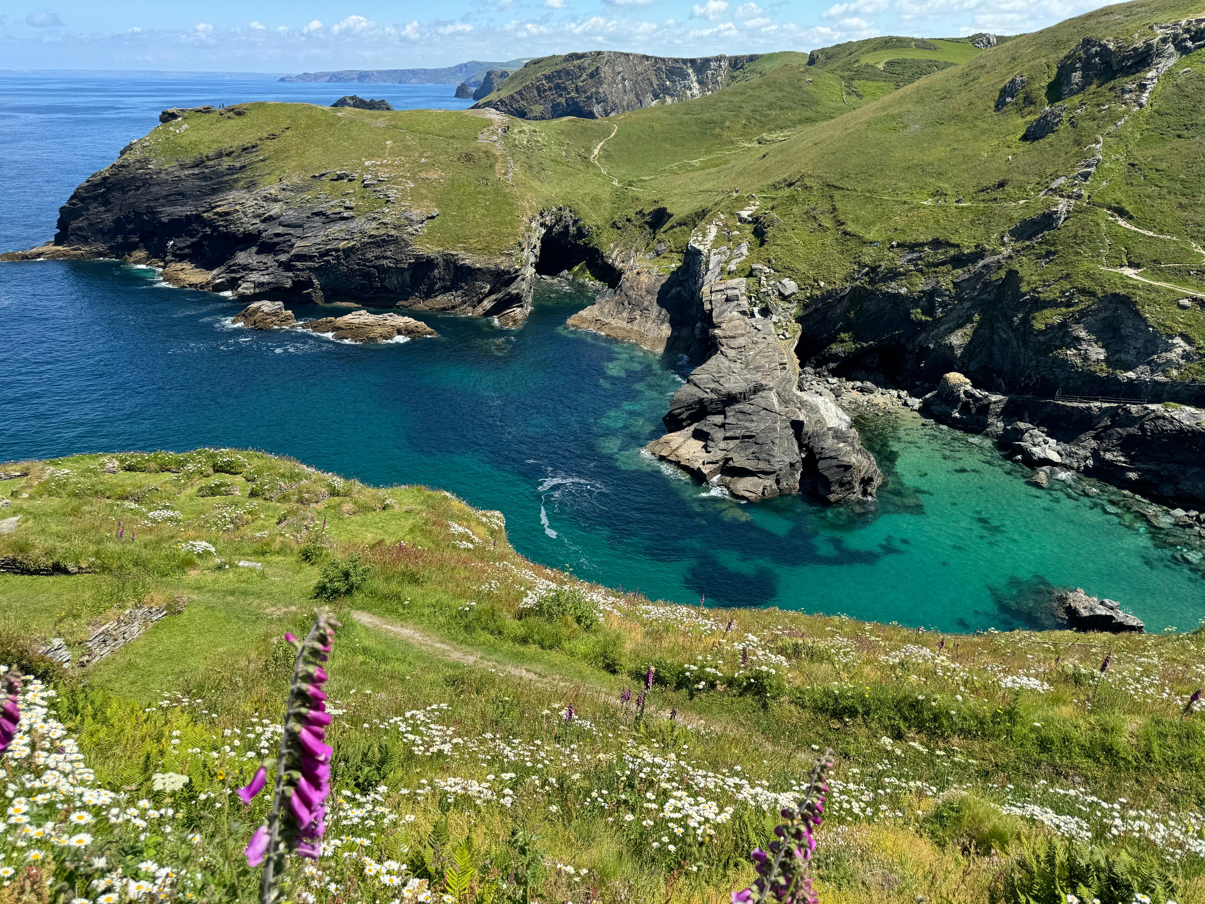
The first day begins in the picturesque harbour village of Boscastle, a natural inlet framed by rugged cliffs and full of characterful old buildings now home to cosy pubs, cafés, and shops. From the south side of the harbour, cross the stone bridge and begin your climb towards the striking white watchtower on Willapark Headland, once a lookout for smugglers. The path then cuts across open headland, dipping and rising past Grower Gut, Trevalga, and Firebeacon Hill, where you can spot the natural rock arch known as Ladies Window in the gully below. A descent brings you into the enchanting Rocky Valley, its mossy gorge carved by rushing water, before the trail climbs again along Bossiney Common, with wide views over the coast and the sandy bay of Bossiney Haven below. Continue on to another windswept headland with far-reaching sea views, before reaching Barras Nose, a rugged promontory offering the first glimpses of Tintagel Castle in the distance. From here, the trail descends to Tintagel Haven, just below the castle ruins. At the castle, you can pay to cross the dramatic English Heritage footbridge—a striking modern structure that reconnects the mainland to Tintagel Island. Designed to blend into the landscape, the bridge is paved with Cornish Delabole slate and features stainless steel balustrades designed to be so fine they almost vanish against the sky.
Stay, Eat & Do
If you’re looking for a low cost stay, check out Dolphin Backpackers where there’s a shared dormitory or enjoy basic camping facilities at the Little Clifden Campsite on a nearby dairy farm. There’s a warm welcome waiting for you at Bosayne Guest House or enjoy your own shepherd’s hut at Cabin Beaver, complete with kitchenette, bathroom and laundry facilities. Head a further 2.2 miles down the Path to discover The Port William at Trebarwith Strand for rooms and pub grub. Don’t forget to grab a couple of famous Pengenna Pasties at their Tintagel shop to put in your rucksack for the next stretch and call in here or the Tintagel visitor centre for your passport stamp.
Day 2 / Section 17 – Tintagel to Port Isaac
Severe – 9.1 miles
“The path dropped quickly down into the narrow inlet of Trebarwith Strand. The patchy white clouds were inviting, but the storms had left the sea raging, forcing itself violently on to the rocky shore. A tiny café offered a cone of chips for a pound. We had five pounds seventy-five left, so rashly ordered two, plus two mugs of hot water, and sat down amongst the surfers, just out of reach of the waves.”
© Raynor Winn, The Salt Path, 2018
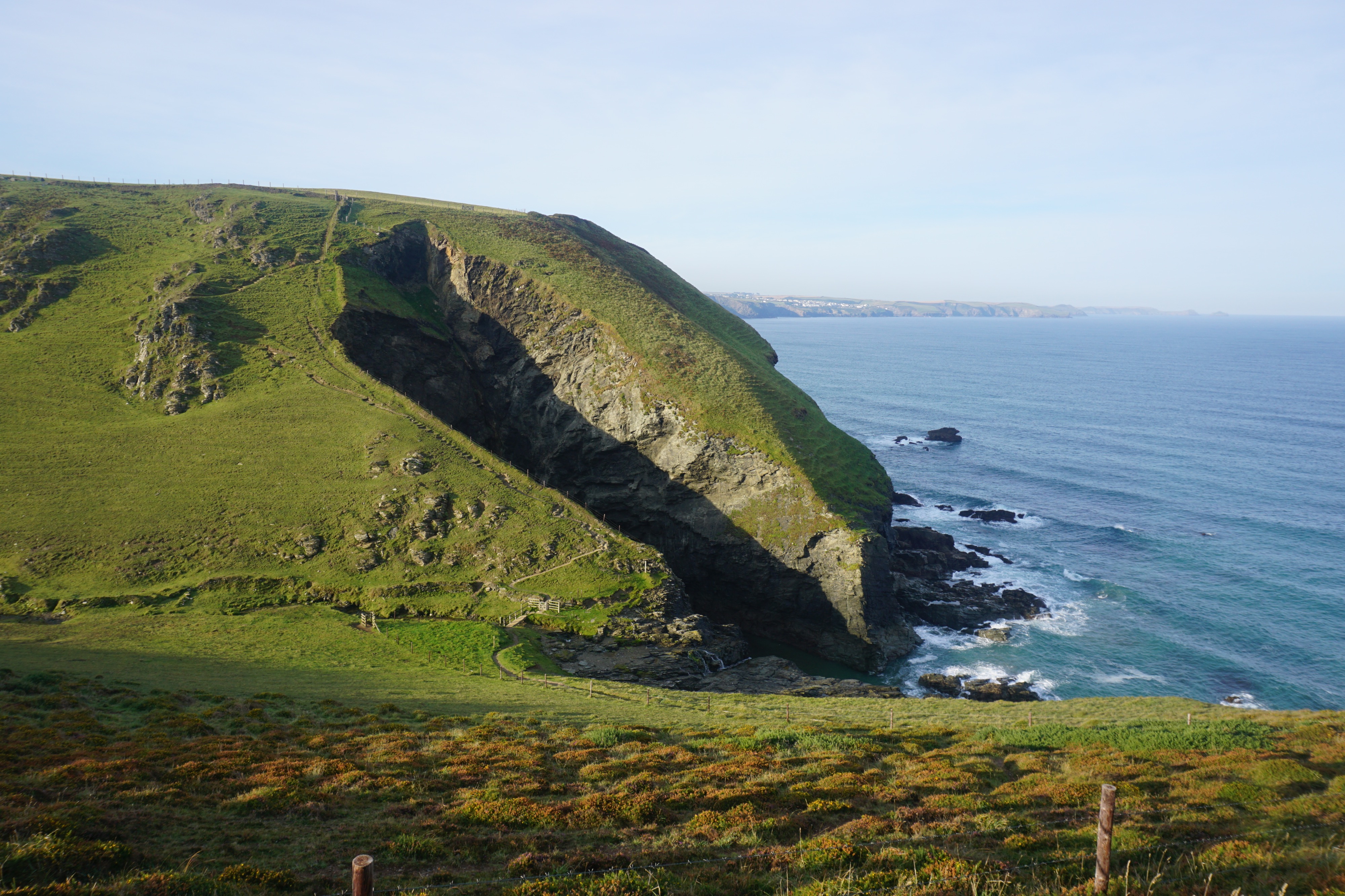
This next challenging stretch is not for the faint-hearted, but the rewards are more than worth the effort: sweeping sea views, dramatic cliffs, sheltered coves, and the picture-perfect fishing village of Port Isaac as your final stop. The route begins with a climb out of Tintagel, skirting the historic St Materiana’s Church and rounding Penhallic Point, where panoramic coastal views greet you. For the next 2.5 miles, enjoy relatively easy walking along the clifftops before a steep descent into Trebarwith Strand. Here is your last chance for toilets, a pub, and refreshments before Port Isaac. From Trebarwith, the walk becomes more demanding, climbing sharply out of Trebarwith Valley before descending again to Backways Cove, then up once more onto the cliffs. A short, flatter section offers some relief before another drop to the stream valley behind Tregardock Beach. The route skirts inland past ‘The Mountain’, a dramatic detached cliff stack, before ascending again to Tregardock Cliff. Next comes the steepest and deepest valley of the day at Jacket’s Point. This coastline, designated both a Heritage Coast and National Landscape, has a rich industrial history. Look out for the remains of old slate workings and fish cellars along the path. Eventually, the path begins to level out across cliff-top meadows. One final dip through the valley at St Illickswell Gug brings you to Port Gaverne, and then it’s a final gentle climb into Port Isaac. This beautifully preserved harbour village, with its beautiful alleyways, listed buildings and harbourside cafes, is a welcome sight after a hard day’s hiking. TV fans may recognise it as the fictional Portwenn from the Doc Martin series.
Stay, Eat & Do
Enjoy great views and a comfy night’s stay at Chicago House B&B or head in-land slightly to Trewetha Cottage B&B for a stunning location (lifts from Path offered by owner). The Slipway offers both stunning sea view rooms and indoor/outdoor dining in the heart of the village. Finish off with a pint in the historic Golden Lion pub which featured in both Doc Martin and The Fisherman’s Friends movie.
Day 3 / Section 18 – Port Isaac to Padstow
Strenuous / Easy – 11.7 miles
“A kestrel that had hung in the sky for an endless time quietly landed on the fence ahead, the early-evening sun lighting his back in a russet glow. We hesitated before passing, not wanting to disturb him. As if sensing our indecision, he lifted off, circling and then landing on a rock just behind us. We carried on.”
© Raynor Winn, The Salt Path, 2018
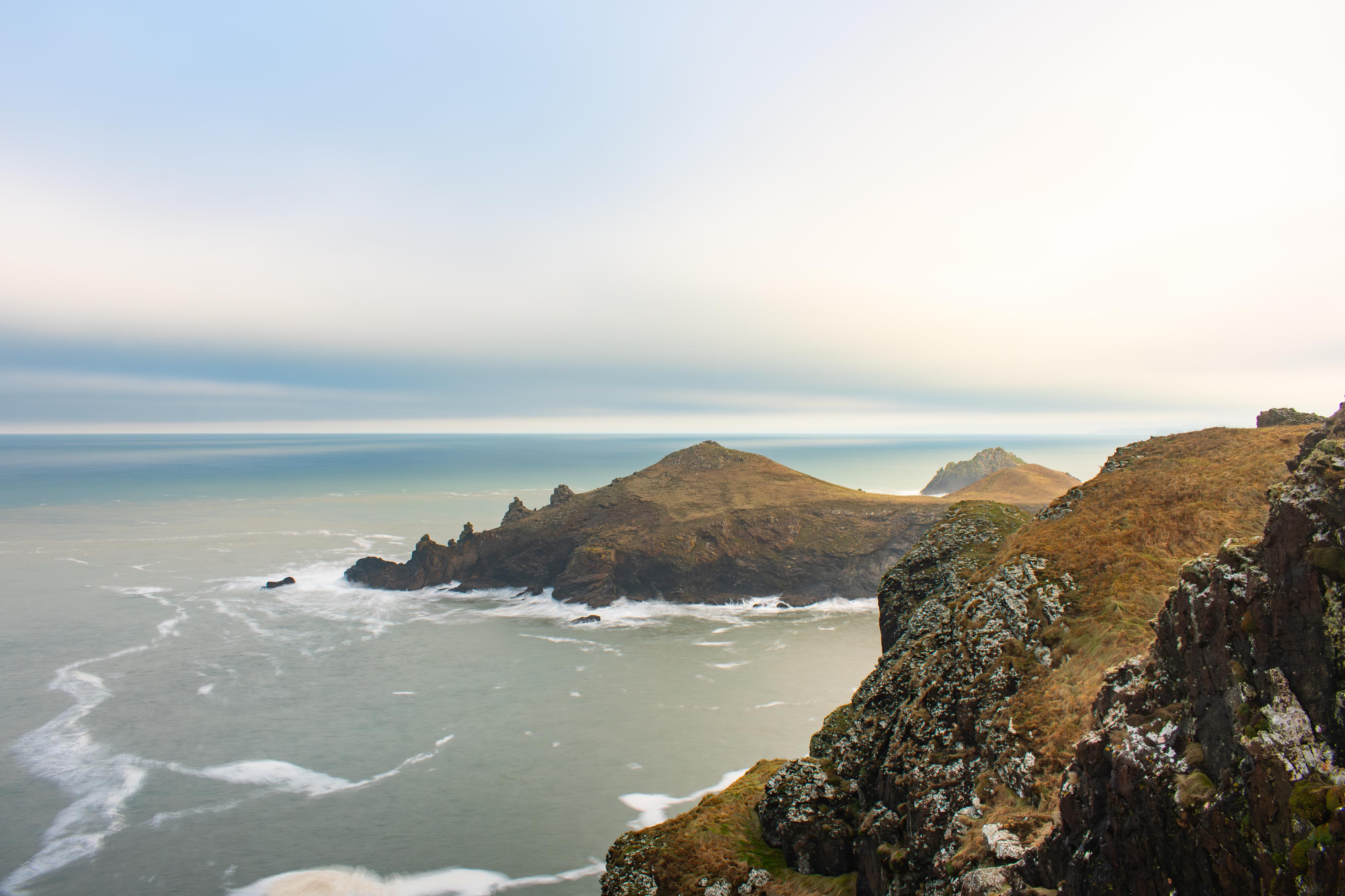
Your final day takes in some truly beautiful, unspoiled sections of the coastline, including remote coves, open headlands, and sweeping sea views. It’s a day of three parts: a rugged, rollercoaster route to Port Quin, followed by open, scenic walking including the broad headland of the Rumps and Pentire Point, ending with estuarine walking reaching the mouth of the River Camel. Leaving Port Isaac, the path climbs from behind the fish market onto the cliffs, with a short descent into the peaceful, tucked-away inlet of Pine Haven. From here to Port Quin, the path is dramatic but challenging, hugging the cliff edge with breathtaking views. There’s an optional detour out to Varley Head for those keen on a longer loop. Dropping into the historic harbour of Port Quin, once a bustling pilchard port, you’ll then tackle a steep climb up a narrow road towards Doyden Point. From a prominent stone cairn, you can take a short diversion to visit Doyden Castle, a 19th-century clifftop folly with superb views back towards the inlet. Beyond here, the path passes grassy slopes and old mineshafts before descending into the rocky cove at Epphaven. A wooded valley gives way to open clifftop again, where you’ll pass the collapsed sea cave known as Lundy Hole. Soon after, you’ll arrive at The Rumps, a dramatic twin-headland promontory and site of an Iron Age hill fort. From this ancient vantage point, climb through a disused quarry and round Pentire Point, another opportunity to take in spectacular ocean views. From here, the terrain becomes gentler as you descend into Polzeath, a lively seaside village known for its surf beach and relaxed cafés, pubs and shops. The route skirts the car park, climbing gently to a low clifftop path above Daymer Bay, where you’ll find seasonal facilities and access down to the beach. At the far end of Daymer, cross a footbridge and follow the path below Brea Hill, weaving between beach and golf course until you arrive at Rock. Descend to the ferry slipway, where a passenger ferry runs regularly to Padstow during the day (with water taxis available in the evenings, weather and tides permitting). Padstow is a picturesque fishing port steeped in maritime heritage, once home to composer Malcolm Arnold and used as a filming location for The Eagle Has Landed. With its cobbled lanes, working harbour and tempting eateries, it’s the perfect place to end a hard day’s walking.
Stay, Eat & Do
If you fancy a bit of luxury at the end of this stretch, book into the award winning Boutique B&B Hotel, Coswarth House, which includes breakfast at Rick Stein’s café (single night supplement waivered for SWCP walkers). If you’re camping, Dennis Cove Campsite is close to the Harbour and Tregella Place Campsite offers basic camping about 2.5 miles out of town. The Old Custom House on South Quay offers great food and drink (and rooms) or call into Padstow Tasting Rooms to sample the best of local craft beers, wines, ciders and cocktails alongside cold platters and crab sandwiches. Get your passport stamped here or at the National Lobster Hatchery, where you can discover more about marine conservation in the area or at the local National Coastwatch Institute station at Stepper Point, a short walk from the Harbour.
Onward travel
There is no direct bus service between Padstow and Boscastle; However, you can catch a bus to Bodmin Parkway where you can continue your travel by train or bus. Bodmin Parkway is well-connected with rail links to London Paddington, Exeter, Plymouth and Penzance.
Up next: Newquay to Portreath
A Taste of The Salt Path
Plan your trip with the Official Guide to the South West Coast Path. The Official Guide is written and produced by the South West Coast Path Association, the charity that protects and champions Britain’s longest National Trail. Containing 52 days of walks across the entire 630-mile National Trail, tides times, accommodation providers and places to eat and drink, our handy guide is sure to help you on your journey—whether you’re planning a weekend trip or even taking on the entire trail.
Check out places to Stay, Eat & Do on the South West Coast Path, and head to our website to learn more about The Salt Path and to download our press pack.
